Description
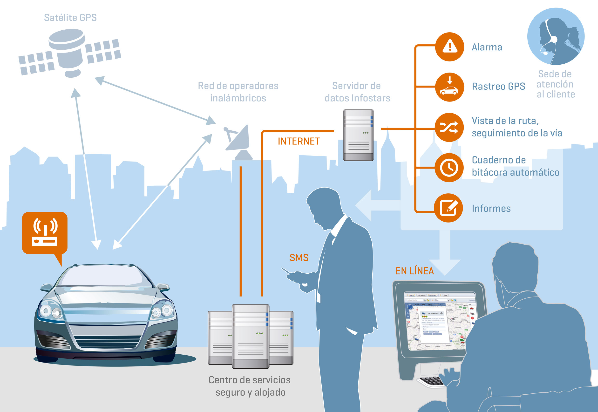
Infostars GPS-Tracking & Tracing Premium
Our GPS Tracking Premium software is the best software from Infostars. It makes fleet management easy and fun. You can use google maps with traffic flow density. The software always shows you the last location fully automatically on a road map or on a satellite map with aerial view. With the 4-level logbook with its proven drill down and drill up function, you can check the plausibility of daily reports in just a few seconds. The track view is linked to the logbook so that you can easily visualise the logbook data on the map. Display the route travelled for up to 62 days at a time on the map. Group vehicles and restrict users to individual vehicle groups using the authorisation system. The alarm module automatically sends you alarms by e-mail or SMS. The maintenance tool simplifies your fleet management by automatically monitoring vehicle data..
- Display of all vehicles on the electronic map (street view/ aerial view Google Maps)
- The last current position of the vehicles is displayed in a clear list
- Displays whether the ignition is sitched on or the vehicle is moving or whether the device is supplied with power
- Display of the address (usually with house number)
- Display of the km/h
- The last 5 or 20 location points can be displayed as a track
- Logbook with kilometres driven including the vehicle’s operating time
- Logbook with 4 summary levels (period, day, journey, location points) for quick & easy checking using drill down and drill up function:
you can switch from one level of detail to the next at the click of a mouse. This function enables a day in the logbook to be checked for plausibility within 5 seconds and all vehicles in the account are displayed and summarised in the period summary. This makes it easy to check the operating times and kilometres driven by all vehicles at the same time. The list can be sorted according to the values so that, for example, the vehicles with the highest mileage are displayed at the top. The time period for this view is freely selectable. It can be a month or a week or Friday 16:00 to Monday 04:00. Since only one line per vehicle is displayed in the period summary, the data is perfectly prepared for a plausibility check. If you now need more information, you can switch to the next level of detail – daily summary – with a click of the mouse. The daily summary clearly displays the first start and last stop per day as well as the daily kilometre performance in one line. This allows payroll accounting to compare a daily report at a glance, and from this summary onwards, the vehicle’s track or route can be displayed for up to 62 days in a row. This gives you a visualisation of the vehicle’s area of operation. For example, if there is a track outside the usual area of operation, you can find out when and where this was at the click of a mouse. If this is still not informative enough, you can display the data for the day in question in the day detail view with a click of the mouse. If there are any uncertainties during the plausibility check, you can switch to the next level with a click of the mouse – day detail view. In the day detail view, you can now see every single journey for the day. Always divided into start location and start time, stop location and stop time, journey time, standing time, kilometres travelled, average speed. The times and locations are also displayed separately for additional information such as movement, blue light on, craning, etc.. This makes it possible to evaluate whether a vehicle has the ignition on and is also moving or how often and where the lorry has tipped over. This view can be switched to a bar view so that the journey times, movement and other information can be read off visually extremely easily, and you can switch from the day detail view to the view of the individual tracking points. You can also see the speed and address at the time of tracking. You can display this point on the electronic map with a click of the mouse, and the logbook can be restricted using the zone filter. This means that in the view and also in the PDF report, you will only see the vehicles that have driven into or out of this zone in the selected time period. This makes it very easy to carry out site recalculations. - Track view of the vehicle. Route/track travelled can be displayed on the map for up to 62 days.
- Information about waiting times
- Search function for addresses
- Simple routing in the DispoLight view
- Logbook in 2 views: numerical and in bars
- The smartphone’s own position can also be displayed
- Map can be switched between street view and aerial view (google Maps)
- Traffic flow density from Google
- Vehicle tree for selecting and filtering individual or multiple vehicles
- Vehicles can be grouped according to several criteria (branch, device type, drive type, etc.)
- Icons for display: icons indicating the direction of travel, or vehicle symbols or a combination of numbers and digits.
- Simcard basic fee
- Data transfer costs in EU countries incl. Switzerland, GB and in 172 countries worldwide with standard configuration. The country coverage is subject to change. The current list is available from Infostars Support.
- Server utilisation costs
- Software updates
- Authorisation system (vehicle groups)
- Create zones (can be used as geofences in conjunction with AlarmStar). The zones can be displayed on the electronic map.
- Zone name is displayed in addition to the address
- Automatic updating of positions
- “Follow” function (vehicle remains in the centre of the map after each refresh)
- Filter functions (time, zones, geofences, vehicles, vehicle groups, map section, vehicle name) for list, map and logbook
- Export of logbook data via CSV to Excel
- E-mail export of logbook data as PDF
- Alarm sending and notification modul
- Maintenance tool modul
- Data storage 183 days
- setup users
- Helpdesk by phone and e-mail from Monday to Friday from 9:00 to 16:00(ETC) except on Austrian bankholidays.
